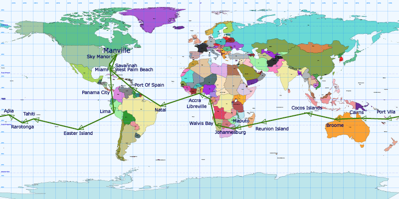
Description
Figuring out a way across Northern Australia
Our route could be summed up by the words "West along the Tropic of Capricorn". Flying westward
gives us more daylight and by staying within the Tropics, we can take advantage of the Trade Winds.
We will join the Tropic of Capricorn by flying South to Easter Island by way of Miami, Panama and
Lima, Peru. From Easter Island, we will continue our Pacific crossing through French Polynesia, the
Cook Islands, Western Samoa and Vanuatu, completing the crossing in Australia. We will cross
Northern Australia and then start our Indian Ocean crossing by flying to the Cocos Islands, a few
hundred miles South-West of Sumatra, then on to Mauritius to finally reach the African Continent in
Mozambique. From there, we will cross over to the Atlantic shore and land in Namibia, and follow the
coast North to Gabon and Ghana. The South American shore will then be within reach and Natal,
Brazil, will be our entry point on the American Continent. Following the Northeastern shore of South
America, we will stop on the Island of Trinidad next, and then enter the United States in
Charleston, South Carolina. A "short" hop will bring us back to New Jersey.
In all, we will make twenty stops in six weeks and will cover over 30,000 statute miles.
The normal weather conditions for July and August over the route described are probably the most
favorable weather conditions to be found throughout the whole year. The largest yet isolated storms of
the whole trip will be found near Nicaragua, Costa Rica and Panama. The weather dries quickly south of
the Columbian west coast. Average but not excessive rains are to be expected at Easter Island, then
generally dry favorable conditions are to be expected to Samoa. Some stormy weather may be encountered
over the western Pacific near Vanuatu and the Solomon's, just east of the Coral Sea. Very dry conditions
are the norm across northern Australia and even most of the way to the Cocos Island of the Indian Ocean.
Very dry conditions will exist from Mauritius to Madagascar and south and west Africa. The "Great Rains"
of the southwest African coast are to be entirely avoided, as they are most active in May and June.
August weather norms over Ghana and The Ivory Coast see nearly one inch of rainfall for the whole month.
The route from Africa to Brazil will most likely show minimal weather until close to the South American
Continent. Some of the heaviest weather to be encountered will be from Brazil to Trinidad, with the
northeast South American coast most active with afternoon and evening thunderstorms. From Trinidad to
South Carolina, crossing the Caribbean, this area is in Atlantic Hurricane Season. Ample weather
information will be available for this leg and simple avoidance is the key.
Winds aloft are most favorable throughout the whole trip averaging a tailwind of about 10 to 15 knots.
All in all, weather and wind wise, this is an optimum time to do this trip. Bear in mind that local
weather nuances may play a factor in actual weather conditions encountered, but this is most definitely
the best time of year to complete this mission.
Leg Summary
The table below shows the estimated and actual flight data. Estimated distances assume Great Circle
routes, the shortest distance between two points on the Earth. Actual distances will vary with
routing and actual time en route depends on the winds encountered.
The following abbreviations are used throughout:
| NM: |
Nautical Miles (1 NM = 1.852 km = 1.15 Statute Mile) |
| ETD/ATD: |
Estimated/Actual Time of Departure |
| ETE/ATE: |
Estimated/Actual Time En Route |
| ETA/ATA: |
Estimated/Actual Time of Arrival |
| USG: |
US Gallon (1 USG = 3.79 liter) |
Airport local time offset from UTC (Coordinated Universal Time) is shown next to airport name.
Departure and Arrival times are local, with Zulu time (UTC) in parenthesis. +1 indicates next
day, -1 indicates previous day. For an example, see Samoa to Vanuatu leg, where they will cross
the date line.
To find out the current time at a given location, go to
www.worldtime.com, www.worldtimezone.com
or click on UTC time difference next to city.
| Date |
From |
To |
Distance (NM) |
Total Dist. (NM) |
Max Speed(KT) |
Max Alt.(FT) |
|
ETD |
ETE |
ETA |
Est. Fuel (USG) |
ATD |
ATE |
ATA |
Tot. Time |
Act. Dist.(NM) |
Tot. Act. Dist.(NM) |
Avg Speed(KT) |
|
| Sat 07/03 |
47N - Manville, NJ, United States / UTC -04:00 DST |
KTMB - Miami, FL, United States / UTC -04:00 DST |
938 |
938 |
177 |
9,070 |
|
09:00 (13:00Z) |
06:15 |
15:15 (19:15Z) |
100 |
09:42 (13:42Z) |
07:35 |
17:17 (21:17Z) |
07:35 |
1,038 |
1,038 |
137 |
|
| Sun 07/04 |
KTMB - Miami, FL, United States / UTC -04:00 DST |
MPMG - Panama City, Panama / UTC -05:00 |
998 |
1,935 |
185 |
12,227 |
|
09:00 (13:00Z) |
06:39 |
14:39 (19:39Z) |
106 |
06:47 (10:47Z) |
07:25 |
13:12 (18:12Z) |
15:00 |
1,035 |
2,073 |
140 |
|
| Tue 07/06 |
MPMG - Panama City, Panama / UTC -05:00 |
SPIM - Lima, Peru / UTC -05:00 |
1,262 |
3,198 |
171 |
11,808 |
|
08:00 (13:00Z) |
08:24 |
16:24 (21:24Z) |
135 |
07:52 (12:52Z) |
09:50 |
17:42 (22:42Z) |
24:50 |
1,355 |
3,428 |
138 |
|
| Thu 07/08 |
SPIM - Lima, Peru / UTC -05:00 |
SCIP - Easter Island, Chile / UTC -06:00 |
2,033 |
5,230 |
176 |
11,414 |
|
06:00 (11:00Z) |
13:33 |
18:33 (+1 00:33Z) |
217 |
07:02 (12:02Z) |
15:19 |
21:21 (+1 03:21Z) |
40:09 |
2,069 |
5,497 |
135 |
|
| Sun 07/11 |
SCIP - Easter Island, Chile / UTC -06:00 |
NTAA - Tahiti, French Polynesia / UTC -10:00 |
2,297 |
7,527 |
164 |
6,685 |
|
05:00 (11:00Z) |
15:18 |
16:18 (+1 02:18Z) |
245 |
06:07 (12:07Z) |
19:00 |
21:07 (+1 07:07Z) |
59:09 |
2,335 |
7,832 |
123 |
|
| Mon 07/12 |
NTAA - Tahiti, French Polynesia / UTC -10:00 |
NCRG - Rarotonga, Cook Islands / UTC -10:00 |
618 |
8,145 |
171 |
8,502 |
|
09:00 (19:00Z) |
04:07 |
13:07 (23:07Z) |
66 |
11:23 (21:23Z) |
04:57 |
16:20 (+1 02:20Z) |
64:06 |
653 |
8,485 |
132 |
|
| Thu 07/15 |
NCRG - Rarotonga, Cook Islands / UTC -10:00 |
NSFA - Apia, Samoa / UTC -11:00 |
826 |
8,971 |
187 |
8,532 |
|
09:00 (19:00Z) |
05:30 |
13:30 (+1 00:30Z) |
88 |
09:40 (19:40Z) |
06:14 |
14:54 (+1 01:54Z) |
70:20 |
847 |
9,332 |
136 |
|
| Sat 07/17 |
NSFA - Apia, Samoa / UTC -11:00 |
NVVV - Port Vila, Vanuatu / UTC +11:00 |
1,161 |
10,132 |
175 |
8,560 |
|
09:00 (20:00Z) |
07:44 |
+1 14:44 (+1 03:44Z) |
124 |
09:29 (20:29Z) |
08:54 |
+1 16:23 (+1 05:23Z) |
79:14 |
1,190 |
10,522 |
134 |
|
| Tue 07/20 |
NVVV - Port Vila, Vanuatu / UTC +11:00 |
YBCS - Cairns, QL, Australia / UTC +10:00 |
1,296 |
11,428 |
179 |
8,598 |
|
08:00 (-1 21:00Z) |
08:38 |
15:38 (05:38Z) |
138 |
08:41 (-1 21:41Z) |
10:06 |
17:47 (07:47Z) |
89:20 |
1,339 |
11,861 |
133 |
|
| Sat 07/24 |
YBCS - Cairns, QL, Australia / UTC +10:00 |
YBRM - Broome, WA, Australia / UTC +08:00 |
1,350 |
12,778 |
177 |
6,436 |
|
07:00 (-1 21:00Z) |
09:00 |
14:00 (06:00Z) |
144 |
09:01 (-1 23:01Z) |
09:27 |
16:28 (08:28Z) |
98:47 |
1,350 |
13,211 |
143 |
|
| Mon 07/26 |
YBRM - Broome, WA, Australia / UTC +08:00 |
YPCC - Cocos Islands, Australia / UTC +06:30 |
1,513 |
14,290 |
174 |
6,679 |
|
07:00 (-1 23:00Z) |
10:04 |
15:34 (09:04Z) |
161 |
09:11 (01:11Z) |
10:59 |
18:40 (12:10Z) |
109:46 |
1,513 |
14,724 |
138 |
|
| Wed 07/28 |
YPCC - Cocos Islands, Australia / UTC +06:30 |
FMEE - Reunion Island, Réunion / UTC +04:00 |
2,431 |
16,721 |
189 |
8,650 |
|
05:00 (-1 22:30Z) |
16:12 |
18:42 (14:42Z) |
259 |
07:19 (00:49Z) |
16:28 |
21:17 (17:17Z) |
126:14 |
2,454 |
17,178 |
149 |
|
| Sat 07/31 |
FMEE - Reunion Island, Réunion / UTC +04:00 |
FQMA - Maputo, Mozambique / UTC +02:00 |
1,299 |
18,020 |
165 |
10,347 |
|
08:30 (04:30Z) |
08:39 |
15:09 (13:09Z) |
139 |
08:17 (04:17Z) |
09:54 |
16:11 (14:11Z) |
136:08 |
1,361 |
18,539 |
137 |
|
| Sun 08/01 |
FQMA - Maputo, Mozambique / UTC +02:00 |
FALA - Johannesburg, South Africa / UTC +02:00 |
251 |
18,272 |
165 |
10,715 |
|
09:00 (07:00Z) |
01:40 |
10:40 (08:40Z) |
27 |
12:45 (10:45Z) |
02:15 |
15:00 (13:00Z) |
138:23 |
270 |
18,809 |
120 |
|
| Tue 08/03 |
FALA - Johannesburg, South Africa / UTC +02:00 |
FYWB - Walvis Bay, Namibia / UTC +01:00 |
748 |
19,020 |
169 |
10,817 |
|
09:00 (07:00Z) |
04:59 |
12:59 (11:59Z) |
80 |
10:47 (08:47Z) |
06:02 |
15:49 (14:49Z) |
144:25 |
766 |
19,575 |
127 |
|
| Thu 08/05 |
FYWB - Walvis Bay, Namibia / UTC +01:00 |
FOOL - Libreville, Gabon / UTC +01:00 |
1,433 |
20,453 |
178 |
12,288 |
|
07:00 (06:00Z) |
09:33 |
16:33 (15:33Z) |
153 |
09:25 (08:25Z) |
10:33 |
19:58 (18:58Z) |
154:58 |
1,515 |
21,090 |
144 |
|
| Fri 08/06 |
FOOL - Libreville, Gabon / UTC +01:00 |
DGAA - Accra, Ghana / UTC +00:00 |
652 |
21,105 |
167 |
8,611 |
|
09:00 (08:00Z) |
04:20 |
12:20 (12:20Z) |
70 |
10:33 (09:33Z) |
05:50 |
15:23 (15:23Z) |
160:48 |
811 |
21,901 |
139 |
|
| Sun 08/08 |
DGAA - Accra, Ghana / UTC +00:00 |
SBNT - Natal, RN, Brazil / UTC -03:00 |
2,215 |
23,319 |
180 |
8,611 |
|
07:00 (07:00Z) |
14:45 |
18:45 (21:45Z) |
236 |
06:32 (06:32Z) |
15:28 |
19:00 (22:00Z) |
176:16 |
2,245 |
24,146 |
145 |
|
| Tue 08/10 |
SBNT - Natal, RN, Brazil / UTC -03:00 |
TTPP - Port Of Spain, Trinidad and Tobago / UTC -04:00 |
1,847 |
25,166 |
199 |
10,987 |
|
07:00 (10:00Z) |
12:18 |
18:18 (22:18Z) |
197 |
08:31 (11:31Z) |
12:38 |
20:09 (+1 00:09Z) |
188:54 |
1,949 |
26,095 |
154 |
|
| Thu 08/12 |
TTPP - Port Of Spain, Trinidad and Tobago / UTC -04:00 |
KPBI - West Palm Beach, FL, United States / UTC -04:00 DST |
1,434 |
26,599 |
174 |
10,762 |
|
08:00 (12:00Z) |
09:33 |
17:33 (21:33Z) |
153 |
08:23 (12:23Z) |
10:21 |
18:44 (22:44Z) |
199:15 |
1,511 |
27,606 |
146 |
|
| Thu 08/12 |
KPBI - West Palm Beach, FL, United States / UTC -04:00 DST |
KSAV - Savannah, FL, United States / UTC -04:00 DST |
331 |
26,930 |
191 |
7,082 |
|
20:00 (+1 00:00Z) |
02:12 |
22:12 (+1 02:12Z) |
35 |
19:51 (23:51Z) |
02:14 |
22:05 (+1 02:05Z) |
201:29 |
344 |
27,950 |
154 |
|
| Fri 08/13 |
KSAV - Savannah, FL, United States / UTC -04:00 DST |
N40 - Sky Manor, NJ, United States / UTC -04:00 DST |
588 |
27,519 |
191 |
7,438 |
|
08:00 (12:00Z) |
03:55 |
11:55 (15:55Z) |
63 |
10:29 (14:29Z) |
04:14 |
14:43 (18:43Z) |
205:43 |
656 |
28,606 |
155 |
|
| Sat 08/14 |
N40 - Sky Manor, NJ, United States / UTC -04:00 DST |
47N - Manville, NJ, United States / UTC -04:00 DST |
18 |
27,536 |
134 |
2,153 |
|
08:00 (12:00Z) |
00:07 |
08:07 (12:07Z) |
2 |
13:40 (17:40Z) |
00:17 |
13:57 (17:57Z) |
206:00 |
31 |
28,637 |
109 |
|